Connected and Automated Vehicles

Infrastructure Planning

WisDOT is researching connected vehicle technologies and how those could be used to enhance the transportation system. Infrastructure should be updated to take advantage of new safety systems on vehicles which can improve safety for all users.

​​

Connect 2050’s vision statement serves as WisDOT’s guiding vision for Wisconsin’s entire multimodal transportation system as it is developed and maintained over time:

WisDOT envisions an integrated multimodal transportation system that maximizes the safe and efficient movement of people and products throughout the state in a way that enhances economic productivity, transportation accessibility and the quality of Wisconsin’s communities while minimizing impacts on the natural environment and socioeconomic, historic, and cultural resources.

WisDOT’s CAV efforts support the vision and goals of Connect 2050, WisDOT’s multimodal long-range transportation plan, including:

Goal 3. Pursue continuous improvement and expand data-driven decision-making processes

Connected vehicle data will provide a large amount of information about traffic operations and road design that will facilitate new improvements in transportation

Goal 5: Maximize technology benefits

Improvements like high-contrast lane markings and other infrastructure can support current and future vehicle automation. Alert systems like WI511 that already provide traveler information through apps can be integrated into new vehicle communication systems and supported by the statewide Traffic Management Center

Goal 6. Maximize transportation safety

Automated vehicles have the potential to significantly reduce human error caused crashes and fatalities while future connected vehicles will be able to communicate and coordinate in traffic thereby also reducing human error caused crashes even before automated vehicles are available

For more information on the vision for Wisconsin’s transportation future, please see the Connect 2050 website.

The WisDOT Work Zone Data Exchange demonstration project is a USDOT sponsored research project designed to test the real-world application of a standard WZDx specification that enables infrastructure owners and operators to make work zone data available for third party use. The objective is to make travel on public roads safer and more efficient through access to data on work zone activity. Specifically, the project aims to get data on work zones into vehicles to help automated driving systems (ADS) and human drivers navigate more safely.work zone data investment chart

The WisDOT Work Zone Data Exchange Phase 2 demonstration project is a USDOT sponsored research project designed to build on the information system from Phase 1 and extend the application to adjacent local roads.

  • Collaboration with UW-Madison, Arcadis/IBI Group, Columbia County, and WisDOT Major Projects section
  • Planning and Prototypingwhatr is WZD infographic
    • What is the Problem WisDOT is trying to solve?
    • Local road closure information shared
    • Streamlined process
    • Migration of local road closures to notification system
    • Cumbersome process now
  • What do we need to test?
    • Smart WZ ITS devices on local Roads
    • WZDx Feed with Smart WZ ITS Devices from Local Roads
I-894 adjacent project map

Phase 2 project on Ryan Rd (STH 100) near I-41/94 in Oak Creek is intended to test collection of traffic information in real time and communication with connected vehicles. Phase 2 is a field deployment on STH 100 or Ryan Road in the City of Oak Creek, focusing on an arterial deployment scenario. Eight roadside units were installed at WisDOT traffic signals along this arterial highway in Milwaukee County.

  • STH 100 Intersections:Phase 2 Ryan Rd map view
    • STH 241 (27th Street)
    • 22nd Street
    • 20th Street
    • I-94 Interchange
    • CTY V (13th Street)
    • 13th Street @ Kwik Trip
    • Bartel Court
    • STH 38 (S Howell Avenue)

ATMA pilot is intended to test the concept and benefits of a driverless ATMA that follows mobile work crews providing a crash absorbing vehicle without a driver to keep mobile road crews safe.

Truck Mounted crash Attenuator (TMA) is a device that is attached to a trailer/truck that absorbs impacts from oncoming vehicles to prevent serious damage to both the motorist and the structure involved in the collision.

No one wants to be the driver in the TMA Truck.

WisDOT – 3 TMA hits in 2022 (reported) and 7 near misses/hits reported by several counties (2019-2021)

  • Project collaboration among 5 State DOT’s and academia ATMA pilot crash test
    • Colorado DOT, Minnesota DOT, Oklahoma DOT, Wisconsin DOT
    • Penn State University, UW-Madison, University of Oklahoma
    • Kratos Defense and Royal Truck (manufacturer)
    • 18 month project
crew working sign ATMA pilot program setup

The Traffic Operations and Safety Laboratory (TOPS Lab) at UW-Madison, in partnership with the city of Madison and TAPCO, a Brown Deer-based traffic safety equipment manufacturer and service provider, has created Wisconsin’s first connected corridor along Park Street in Madison.

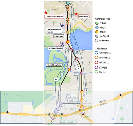
Fifteen intersections along the Park Street corridor now have dual-band dedicated short-range communication (DSRC) roadside units (RSU) that can “talk” to vehicles that have appropriate test equipment as they move through the corridor.

As the vehicles move, they transmit basic safety messages (BSMs) about speed, location and direction of traffic. The intersection is sending back information on signal phasing and timing, often referred to as SPAT messaging. For example, if the traffic signal is red, it informs the vehicle that the light is red, as well as how soon the signal will turn green.

The connected vehicle infrastructure also sends out support messages such as a map of the intersection, so a connected vehicle knows what lane it’s in and whether that lane is used for turning. The Madison Park Street project is valuable not only as a means to collect data in a real-world connected corridor, but to provide the department and researchers opportunities to use that data to explore how to improve traffic safety and flow.

Though cars capable of interfacing with connected infrastructure are uncommon now, these pilot projects provide invaluable information as we prepare for the day connected and automated technologies become more broadly available.

The Park Street connected corridor is the first of its type in the state.

BTO (WisDOT Bureau of Traffic Operations) CV Pilot Project – Phase 3

The Wisconsin Department of Transportation is working with the UW TOPS Lab to expand the Park Street project along two interchanges on Highway 12/18 to capture traffic flow information on Highway 12/18 and integrate the sharing of data between the city system and the state system.

  • Integrates and extends the Madison's Park Street Connected Corridor
  • Includes MMITSS integration
  • WisDOT locations
    • Madison Beltline Interchange with Park St (USH 151)
    • Madison Beltline Interchange with Fish Hatchery Rd
  • Installed and integrated 6 RSUs (roadside radio units)


WisDOT is partnering with the UW Milwaukee - Institute for Physical Infrastructure and Transportation (IPIT) in an effort to look forward to the future of connected vehicle technology data streams. CAV technology from vehicles and infrastructure will have the ability to produce significant amounts of data. What data should be collected and how it should be stored, protected, managed and shared, are all policy questions that need to be addressed.

CV data has the potential to improve traffic management operations, identify roadway design improvements, and provide safety solutions are not currently available. Along with these benefits come issues regarding privacy, ownership, and cyber-security concerns.

A robust management and policy framework is needed to safeguard, prioritize, manage and evaluate what data is collected and how it is to be used. WisDOT and IPIT are continuing to explore how to best manage these new data opportunities and issues.

WisDOT collaborates with other Midwest state DOTs which are working on numerous CAV projects. The results of these research and pilot projects are shared with all 10 member states for more efficient .research and best –practices among the states as these new technologies quickly evolve.

MAASTO’s Strategic Plan has identified several key areas of focus:

  • Equity, Access & Engagement
  • Regular Convening and Annual CAV Summit
  • Coordination on Federal Grants
  • DOT Organizational Readiness
  • Data Sharing
  • AV Legislation and Engaging Policy Makers
  • Research
  • AV Freight and Platooning
  • Uniform Minimum Following Distance Platooning Laws
  • Planning and Forecasting
  • Local and Tribal Coordination

Impacts of Automated Vehicles on Highway Infrastructure, FHWA

Publication no. FHWA-HRT-21-015, March 2021​