 The U.S. Bicycle Route System (USBRS) is an evolving network of bicycle routes that are designed to connect rural, urban, and suburban areas. For more information on national USBRS see
Adventure Cycling Association.
The U.S. Bicycle Route System (USBRS) is an evolving network of bicycle routes that are designed to connect rural, urban, and suburban areas. For more information on national USBRS see
Adventure Cycling Association.
Wisconsin has two designated U.S. Bicycle Routes:
USBR 30 and USBR 230.
This is a 269-mile route that connects bicyclists across the state, from east to west, beginning in Milwaukee at the Lake Ferry Express to Bluff Siding, WI on the Mississippi River. USBR 30/230 routes bicyclists on over a 160 miles of Department of Natural Resources (DNR) state trails as well as county or local trails interconnected with roadways for a continuous route.
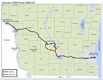
USBR 230 is an alternate route for use when the
Merrimac Ferry (Colsac III) at WIS 113 is not in operation. The route runs along state, county and local roads from Madison to Reedsburg.
GPS files (.fit, .gpx, .tcx) for both routes are available to upload to your GPS application. Additional GPS files are available through a
Ride with GPS map created by Adventure Cycling.
Trails along USBR 30/230
Many of the trails that are encountered along the route were converted former railroad corridors. For more information on these trails please visit the following websites.
For information about the DNR state trails along the route go the
DNR website.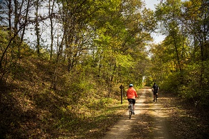
- Hank Aaron State Trail
- Glacial Drumlin State Trail
- Capital City State Trail
- 400’ State Trail
- Elroy Sparta State Trail
- La Crosse River State Trail
- Great River State Trail
County and local trails: