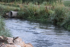
WisDOT manages more than 11,000 miles of state and interstate highway, including numerous drainage systems to help clear stormwater from the driving surface. These systems help keep roadways safe and passable. They also create health benefits for surface and ground waters.
Stormwater Management
Clean water is vital to public health. WisDOT has worked for decades with key stakeholders such as the Wisconsin Department of Natural Resources (WDNR) to ensure appropriate controls and policies. This is because rain, snow and ice eventually turn into surface waters that flow from hard surfaces, such as driveways and streets, into drains and ditches that ultimately lead to natural water systems. Stormwater runoff can carry contaminants such as fertilizer, oil and grease or pet waste. That’s why WisDOT has tapped the environmental expertise of the WDNR for many years to develop solutions that help to clean and filter highway storm runoff.
Elements of the WisDOT Stormwater Management Program include:
- Transportation Separate Storm Sewer System (TS4) permit
- Adopt-a-highway cleanups
- Working to reduce dependence on road salt
- Street-sweeping leaves and debris from urban freeways
- Annual tracking through the TS4 Annual Report to WDNR
- Project-specific stormwater management planning
- GIS mapping to streamline planning and maintenance
- Continued education for engineers and staff
You can help
Cleaner runoff makes for cleaner natural water systems. Here are some tips to consider.
- Promptly fix any vehicle that is leaking oil or other fluids.
- Wash car on grass or gravel when possible to keep water from storm drains.
- Dispose of automotive and household chemicals properly – never down a storm drain.
- Pick up litter, debris and pet waste for proper disposal.
- Use a disposal service or contact your local wastewater plant to handle travel trailer waste.
- If you witness a hazardous spill or illicit discharge, report it to the WDNR at 1-800-943-0003.
Transportation Separate Storm Sewer System (TS4) Permit
State and federal laws require that owners of TS4s have coverage under a stormwater discharge permit to discharge stormwater to waters of the state. The purpose of the stormwater discharge permit is to identify conditions under which stormwater can be discharged to help protect the quality of surface waters, wetlands and groundwater.
WisDOT has received a TS4 state-wide general permit from the Wisconsin Department of Natural Resources (WDNR) formally titled – “General Permit to Discharge Under the Wisconsin Pollutant Discharge Elimination System WPDES Permit No. WI-S066800-2.”
The TS4 Permit is applicable to WisDOT roadway rights-of-way and properties owned, operated and maintained WisDOT that are located within urbanized areas of Wisconsin.
WisDOT's TS4 Permit is modeled on a similar permit that Wisconsin municipalities have used since the 1990s.
Mapping
Civil engineers and environmental staff use various types of maps (topographic, soils, aerial, property divisions, road locations, floodplains, environmental features, etc.) for stormwater management planning, systemwide stormwater analysis and roadway design. These maps can be obtained from County, Municipal, WDNR, NRCS, FEMA and other agencies websites.
In addition, the WisDOT BTS-ESS has created its own Map specific to its stormwater program needs and requirements.
Stormwater & Environmental Map Viewer (revised May 14, 2025).
* Note that the map has recently been migrated to a new computer platform with some difference in the look and feel, but the functionality is similar to the previous version.
The map has layers to depict the following element that are required in the urbanized areas:
- 36-inch diameter and larger storm sewer and culvert outfall locations.
- Drainage areas within the ROW.
- Flow directions and approximate swale locations.
- Average Annual Daily Traffic (AADT).
In addition, the map has layers that depict the following elements that are located across the entire State:
- Stormwater Control Practices (SCPs). This layer includes DOT built SCPs such as wet ponds, dry ponds, infiltration basins, combination ponds, bioretention devices, underground vaults and proprietary devices. The location of the SCPs is shown on the map. Inspection results, if performed on a particular SCP, can be accessed by clicking on the SCP location and clicking on the More Info link in the Dialog Box.
- WisDOT Stormwater Pollution Prevention Plan (SWPPP) layer includes WisDOT owned facilities that have a higher potential for stormwater runoff pollution such as salt storage, equipment and/or material storage facilities. SWPPP reports for all the locations can be accessed by clicking on the SWPPP location and clicking on the 'More Info' link in the Dialog Box.
Available information about each item on the map is available by clicking on the item to open a dialog box.
The map also includes external data layers from the Wisconsin Department of Natural Resources (WDNR) Surface Water Data Viewer and includes impaired waters, TMDL priority areas, outstanding and exceptional resource waters, tribal outstanding and exceptional resource waters, delineated wetlands, ordinary high water mark determinations, FERC project areas, and digital state floodplains, among others. WisDOT is not responsible for the accuracy or functionality of external data.
Please note that this GIS based mapping system is only available to WisDOT staff at this time.
Legal Requirements
-
FDM 10-1-2 Applicable Laws and Regulations
-
TRANS 401 Construction site erosion control and stormwater management
Stormwater Pollution Prevention Plans
 August 29, 2023
Stormwater Pollution Prevention Plans (SWPPPs) have been developed for WisDOT owned properties with activities and operations that have a higher potential to create stormwater runoff pollution such as salt storage, equipment and material storage facilities. A list of the all the SWPPPs is found below:
SWPPP Facilities List August 29, 2023
The SWPPP report documents the existing best management practices (BMPs) the site currently uses to minimize stormwater runoff pollution and proposes other BMPs for the site to implement to further minimize stormwater runoff pollution from the site. The SWPPP report also describes the other requirements for the site such as Annual Site Inspections and Quarterly Wet Weather Inspections.
SWPPP locations and a copy of the SWPPP can be accessed from the Stormwater and Environmental Map Viewer (in the Mapping Section above).
BTS provided an electronic training for the Facility Managers and other interested stakeholders on July 25, 2023. A copy of the PowerPoint Presentation and recording of the Presentation is available below:
Milwaukee River Bacteria TMDL
One of the elements of the Departments TMDL requirements in the TS4 is to create a map and inventory of possible bacteria (fecal coliform and E. coli) sources in the Milwaukee River TMDL watershed that drain to or are adjacent to WisDOT owned highways. Further, if sources are found, then a bacteria management plan would need to be developed.
The first step towards meeting this requirement was completed in January 2025 and is described in the following report:
Milwaukee River Basin Bacteria TMDL Study Drainage Memo, Map and Inventory of Possible Sources, Pilot Study, January 2025 March 25, 2025
Stormwater in the News
2023 Stormwater Week Proclamation
FDM References
Worksheets/forms
See the
forms and tools page for factor sheets and guidance
 Stormwater drainage summary report
Stormwater drainage water quality report
References and tools
FHWA information/guidebooks