The Wisconsin Department of Transportation (WisDOT) is in the process of developing plans for proposed improvements on 4.25 miles of WIS 22 under Project ID 9180-36-00 in Oconto County. The purpose of this website is to provide information regarding the proposed improvements, describe the potential impacts it would have on the community, and offer an opportunity for public comment.
Project location
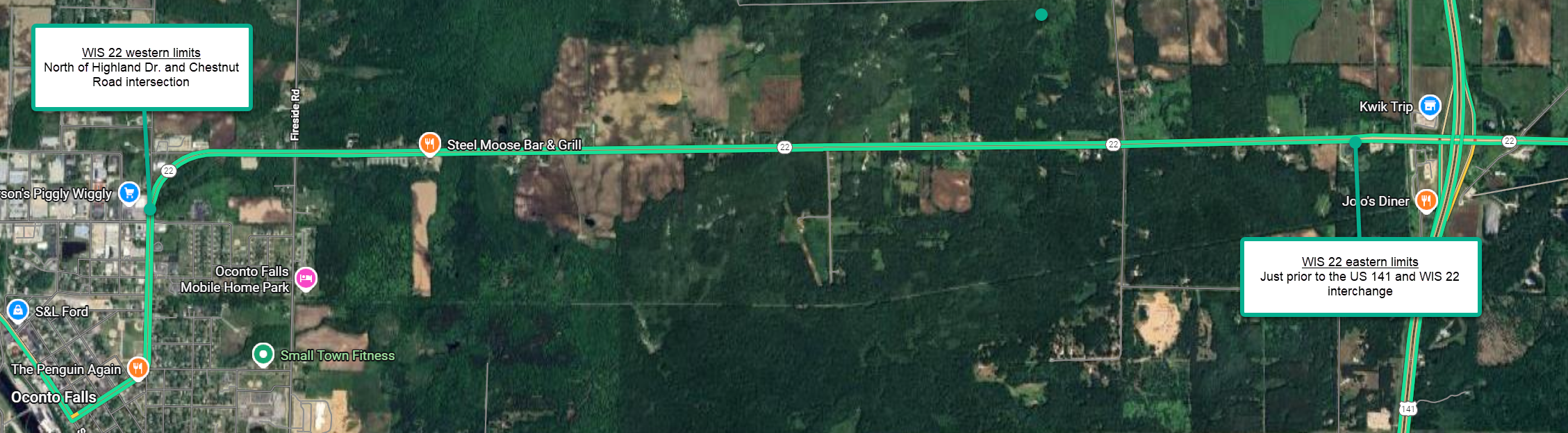
WIS 22 from East Highland Drive in Oconto Falls east to near US 141 in Oconto County.
Project purpose and need
The purpose of the WIS 22 improvements is to extend the life of the roadway and address roadway deterioration. The existing pavement structure is showing signs of distress in the form of longitudinal/transverse cracking. This distress leads to undesirable ride quality, deterioration of the underlying roadway base, and increased maintenance frequency and costs. Additionally, the project is needed to address the paved shoulder width for bicycle accommodations as WIS 22 is on the state bicycle route map. The project will also address poor ditch drainage in two area. The state park and ride lot south of WIS 22 on Duarme Road will also be milled and resurfaced.
Proposed improvements
This is a resurfacing-level project. Proposed improvements include:
- Milling the top 2 inches of existing asphalt and replacing it with 2 inches of new asphalt
- Widening the paved shoulders from 3’ to 5’ for bicycle accommodation
- Perpetuation of the existing mainline and shoulder rumble strips
- Replacing pavement marking
- Minor ditch cleaning in two locations to maintain storm water flowing.
- Park and Ride lot new asphalt surface, pavement markings, signing for ADA parking areas
Anticipated benefits
 The anticipated benefits of this WIS 22 resurfacing project are multifaceted, addressing both immediate roadway conditions and broader user needs.
- By milling the top 2 inches of existing asphalt and replacing it with 2 inches of new asphalt, the project will deliver a significantly smoother riding surface for motorists, reducing vehicle wear and tear, minimizing vibrations, and enhancing overall comfort and fuel efficiency during travel.
- This resurfacing will substantially extend the pavement's service life, preventing further progression of longitudinal and transverse cracking that currently compromises ride quality and accelerates deterioration of the underlying base layers. In turn, these improvements are expected to decrease long-term maintenance frequency and associated costs for the Wisconsin Department of Transportation, allowing resources to be allocated more efficiently elsewhere.
- Widening the paved shoulders from 3 feet to 5 feet will markedly improve safety and accessibility for multi-modal users, particularly bicyclists, as WIS 22 is designated on the state bicycle route map; the enhanced shoulder width provides greater separation from vehicular traffic, reduces the risk of conflicts, and encourages safer bicycle travel along this corridor.
- Retaining and perpetuating the existing mainline and shoulder rumble strips will continue to offer valuable audible and tactile warnings to help prevent lane departures and drowsy driving incidents.
- Minor ditch cleaning in two locations will restore proper stormwater flow, mitigating potential hydroplaning hazards, reducing standing water that could lead to ice formation in winter, and preventing erosion or sediment buildup that might otherwise affect roadway stability.
- Finally, resurfacing the Duarme Road Park and Ride lot south of WIS 22, combined with updated pavement markings and enhanced signing for ADA parking areas, will improve usability and visibility for commuters and those with disabilities, promoting equitable access, better organization of parking spaces, and overall encouragement of carpooling or alternative transportation options at this facility. Collectively, these enhancements will result in a safer, more reliable, and more sustainable segment of WIS 22 for all users.
Proposed traffic impacts
WIS 22 will remain OPEN to traffic with flagging operations during construction. Motorist may encounter minor delays.
Proposed schedule
- Environmental document: May 2027
- Project design: June 2027
- Final Design: May 2028
- Construction currently scheduled in 2030
- Could be advanced to 2029 if funding becomes available
Real estate
No real estate is required for this project.
Business Resource: WisDOT’s In This Together program
WisDOT recognizes businesses located in work zones or impacted by detour routes have special needs. WisDOT's In This Together program is offered to business, organizations and community leaders as an idea source as they plan for road construction in their area. It includes promotional examples, case studies and a specially designed Business Coordination Guide with information on:
- Planning ahead
- Keeping customers informed
- Tips for businesses
- Temporary business signing during construction
- Businesses impacted by highway closures and detours will have an opportunity for temporary business signage during construction.
WisDOT’s In This Together website is located at
www.wisconsindot.gov/Together.
Public input/comments
Your comments assist us in developing a project that will serve the needs of the traveling public, as well as the needs of the local community and are welcomed and appreciated throughout the design process. Below are three ways to provide project comments. Please submit comments to WisDOT using one of the following methods so that we receive them by the comment date to be consider during design.
- Download and fill out the comment form (with prepaid mailer) attached to the WIS 22 public handout (below) and mail to WisDOT contact at address below.
- Email comments or questions to the contact listed below.
- Call the contact below.
Project contact
Kurt Vogel, P.E., Project Manager
Wisconsin Department of Transportation
944 Vanderperren Way
Green Bay, WI 54304
Phone: (920) 362-1732
Email:
kurt.vogel@dot.wi.gov