WISCORS Information |
Benefits of a CORS network |
Partnerships |
Field Components
Overview
The Wisconsin Department of Transportation (WisDOT) Geodetic Surveys Unit is developing a statewide Global Navigation Satellite System (GNSS) reference station network, called the Wisconsin Continuously Operating Reference Stations (WISCORS) Network. This network consists of over 115 permanent GNSS reference stations that can provide GNSS corrections to mobile users in real-time. Mobile users properly equipped to take advantage of these GNSS corrections can position in the field to the 2 centimeter accuracy level in real-time.
The mission of the WisDOT Geodetic Surveys Unit is to apply state-of-the art methods of precise positioning and advanced geodetic techniques to establish and maintain the horizontal and vertical geodetic control infrastructure across the state of Wisconsin. A principal objective in that mission is the establishment and operation of a permanent GNSS CORS network in Wisconsin.
- CORS are established at an approximate 40 to 50 kilometer spacing across the state of Wisconsin.
- Network software is necessary to configure and monitor the quality of data from the reference stations, compute corrections, and output the corrections in real-time to mobile users in the field.
- GNSS-capability: All WISCORS network reference stations utilize three satellite constellations.
- United States NAVSTAR Global Positioning System (GPS)
- Russian Federation global navigation satellite system (GLONASS)
- European Union global navigation satellite system (Galileo)
- work-in-progress toward network-wide availability of Chinese satellite navigation system (BeiDou-3)
- WISCORS reference station data is archived and available online via the WISCORS Web Application.
- New users can request access to the network via the WISCORS Web Application.
Benefits of a CORS Network
- Eliminates the need and cost for another receiver to act as a base.
- Eliminates the resource time associated with equipment setup at the base site.
- Greatly enhances consistency of coordinate determination.
Partnerships
The WisDOT Geodetic Surveys Unit is partnered with the federal government, state and local government agencies, and educational institutions in the development and operation of the system.
Through cooperative agreements, host site partners have agreed to contribute facilities, power, and access to high-speed internet service. WisDOT has supplied nearly all the GNSS hardware, all the materials and supplies to construct the CORS monuments, all the information technology (IT) components and software to operate the system.
Field Components
The WISCORS field components installed at a host site partner facility include:
- Ground based monument (concrete or stainless-steel design) or building mounted monument
- GNSS receiver, GNSS antenna, coaxial cable, plastic conduit, and lightning arrester
- Enclosure boxes to house equipment and electrical components
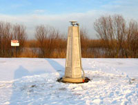 WISCORS concrete pillar monument at Kewaunee, Wis.
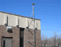 WISCORS building mount monument at Winneconne, Wis.
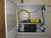 GNSS receiver and battery backup unit installed at a WISCORS host site facility.