The Wisconsin Department of Transportation (WisDOT) is seeking public feedback on proposed improvements to WIS 114 in Winnebago County. This outreach aims to obtain your input on the identified needs and proposed design details. We appreciate your input and encourage you to take a moment to review the project information and provide comments.
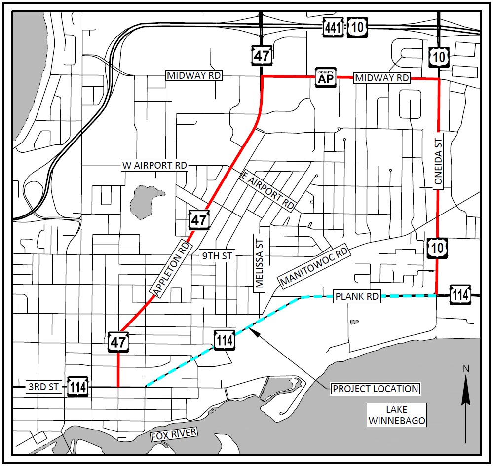
Project location
The proposed project takes place on 1.7 miles of WIS 114 within the city of Menasha and the village of Fox Crossing in Winnebago County. The project limits begin at Manitowoc Street and end at US 10/Oneida Street.
Project purpose and need
The project is needed because the underlying pavement is failing, and the roadway pavement has reached the end of its service life. The last major reconstruction of WIS 114 dates back to the 1930s. The roadway has undergone several rehabilitations, and performing additional rehabilitations is no longer cost-effective.
Project benefits
The reconstructed roadway will provide motorists a smoother riding surface resulting in less wear on vehicles and decreased maintenance costs. Safety reviews at intersections will determine if additional safety modifications are necessary.
Public handout
WisDOT created a public handout for this project. Please feel to download, print and provide to anyone without access to the website. The handout includes a comment form with a prepaid mailer.
Project displays
The project displays below show specific locations of proposed construction operations, right-of-way, typical sections, and property lines. The displays may take a few moments to load.
Proposed improvements
This is a reconstruction-level project. Proposed improvements include:
- Reconstruction of 1.7 miles of roadway, including existing sidewalks and curb ramps.
- Construct new sidewalk on north side of WIS 114 from 6th Street to Melissa Street.
- Repave the asphalt trail on the south side of WIS 114 from Baldwin Street to US 10.
- Replace the deteriorated storm sewer and install new driveway culverts.
- Construct an eastbound left turn at Melissa Street with a median refuge island.
- Construct a new crosswalk with median refuge island on the east leg of the Melissa Street intersection.
- Reduce westbound WIS 114 from three lanes to two lanes west of the US 10/Oneida Street intersection to eliminate the existing double lane drop.
- Enhance on-street bicycle accommodations by widening the paved shoulders along north side of WIS 114 between Melissa Street and US 10/Oneida Street.
- Install new signing and pavement marking.
- Replace the railroad crossing and railroad signals, including constructing bump outs to allow bicyclists to cross the tracks at a better angle.
Drainage Study
A drainage study was completed to review the feasibility of lowering the profile of WIS 114 between 6th Street and US 10. The study determined that the existing roadway elevation is at the approximate 100-year flood elevation of Lake Winnebago and any lowering of the profile between 6th Street and US 10 would result in a roadway that was more susceptible to flooding. The recommendation of the study was to reconstruct the roadway between 6th Street and US 10 at approximately the same elevation as the existing roadway.
Proposed Roadway Typical Sections
Existing and proposed typical highway sections are shown below as images after each section of the roadway is discussed. A PDF document with all the typical sections listed below is available for download as well.
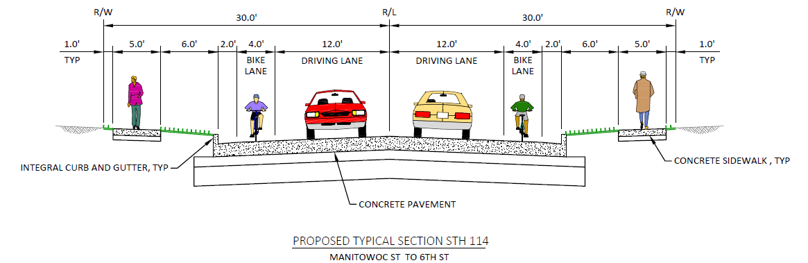
Manitowoc Street – 6th Street (Existing and Proposed)
It is proposed to maintain the existing roadway section that includes a 12’ driving lane, a 4-foot bike lane, 2’ gutter and sidewalks on both sides of the road as shown below.
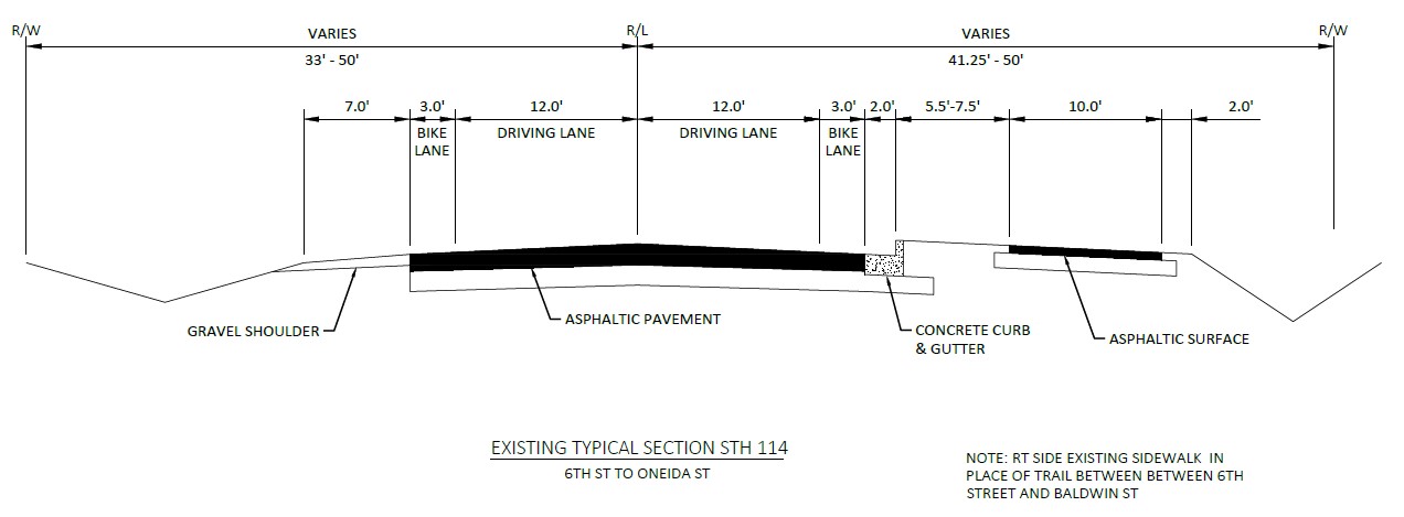
6th Street – US 10 (Existing)
The existing roadway section includes a 3-foot bike lane and 2-foot gutter on the south side of WIS 114 and a 10-foot rural shoulder (3’ paved) on the north side of WIS 114 as shown below.
6th Street – Melissa Street (Proposed)
It is proposed to add curb and gutter and sidewalk along the north side of WIS 114 and construct 4-foot bike lanes with a 2-foot gutter. The ditch will remain in some areas behind the new sidewalk on the north side of WIS 114. The proposed roadway section is shown below.

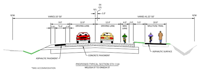
Melissa Street – US 10 (Proposed)
The proposed roadway section increases the bike lane width from 3-foot to 4-foot on the south side of WIS 114 and maintains the rural shoulder on the north side of WIS 114. The finished shoulder width will be 9-feet (7-feet paved). Ditches will be regraded in some areas to improve drainage.
Additional sidewalk
The village of Fox Crossing is not considering the addition of sidewalk on the north side of WIS 114 between Melissa Street and US 10 at this time. The roadway profile cannot be lowered to eliminate the existing ditches due to flooding concerns, and the addition of sidewalk would result in the need to acquire real estate along the north side of WIS 114 to reconstruct the ditches further away from the roadway.
Traffic impacts
WIS 114 will be closed to through traffic and detoured during construction.
- The proposed detour would direct drivers to use Appleton Road/WIS 47, Midway Road/County AP, and Oneida Street/US 10.
- Local access will be maintained to residential driveways when possible.
- Sidewalk construction between Manitowoc Street and 6th Street will be staged to provide pedestrian access along one side of WIS 114 at all times.
- Construction will be staged to minimize the closure of the trail along the south side of WIS 114 between Baldwin Street and US 10.
Schedule
- Public Involvement Meeting: May 2022
- Environmental document: February 2024
- Project design: 2022 – 2027
- Public Involvement Meeting #2: Summer 2025
- Real estate acquisition: Spring 2025 to Spring 2027
- Utility relocations: 2027
- Construction currently scheduled in 2028
Real estate
Real estate acquisition is in progress. Acquisition in the form of Temporary Limited Easements (TLEs) are required to blend the new construction into adjacent properties. Small strips of permanent (FEE) acquisition are also needed.

Business Resource: WisDOT’s In This Together program
WisDOT recognizes businesses located in work zones or impacted by detour routes have special needs. WisDOT's In This Together program is offered to businesses, organizations, and community leaders as an idea source as they plan for road construction in their area. It includes promotional examples, case studies, and a specially designed Business Coordination Guide with information on:
- Planning ahead
- Staying informed
- Keeping customers informed
- Tips for businesses
- Temporary business signage for businesses in the detoured portion of the project limits.
Please see
WisDOT’s In This Together website for more information.
Public input/comments
Please submit comments to WisDOT using one of the following methods so that we receive them by the comment date to be considered during design.
-
Download the WIS 114 public handout and fill out the comment form attached to handout.
- Comment form has prepaid postage. Simply fold and mail.
- Email comments or questions to the contact listed below.
- Call the contact below.
Project contact
Bill Bertrand, P.E., Project Manager
Wisconsin Department of Transportation
944 Vanderperren Way
Green Bay, WI 54304
Phone: (920) 360-3124
Email:
William.bertrand@dot.wi.gov