About the study | About the official mapping process
What is an official map?
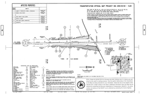
An official map is a recorded document that depicts the location and amount of private land WisDOT will need to purchase in the future for highway right of way. Wisconsin State Statute 84.295 authorizes WisDOT to create such a document, but its use is restricted to freeways and expressways that won’t be built in the relatively near future. It is created only after an extensive study of many issues and coordination with landowners, local governments, agencies and other stakeholders, culminating with a public hearing. An official map cannot be used to purchase the right of way. That requires a plat of right of way, which is created later on, a few years before the physical construction of the freeway or expressway.
Why will WisDOT create an official map?
An official map gives landowners and local governments the ability to plan their futures and develop their lands in ways that avoid the future highway improvements. Developers can be confident that expensive new investments will not be negatively impacted by the new freeway or highway. Local zoning can be altered such that the lands are preserved for future highway use. Ultimately, mapping greatly increases the likelihood that the land needed for the future improvement will remain available and at a reasonable cost, saving taxpayers money and avoiding the need to move the proposed roadway somewhere else that is less desirable.
What will WisDOT officially map?
WisDOT will map and preserve land required to convert US 18/151 to a freeway/expressway under Wisconsin State Statute 84.295 including:
- Interchange locations
- Grade separations (overpass/underpass)
- Removal of existing public road and private driveway access points
- Alterations, removals, or additions to the local road system
How accurate is the official map?
The accuracy varies depending upon circumstances. The accuracy of the US 18/151 official map will be the same as required for final highway plans. This will include the accurate location of all property boundaries and identification of current landowners.
What are the rights of property owners?
If your property falls within the area shown on the WisDOT official map, you will:
- Receive a formal letter form WisDOT informing you of this.
- Have the official map notification recorded on your property.
The only requirement from that point on is that you must notify WisDOT 60 days in advance of any construction on the portion of your property that is within mapped limits. This is defined as erecting or moving in a new structure, or in some way altering an existing one. Upon receipt of that notification from the landowner, WisDOT will make a determination to either purchase the property at fair market value or allow the proposed private alteration to occur. If the property is acquired at later date, the owner will receive full compensation for the alteration.
If a landowner makes any alteration to the mapped portion of the property without providing this notification, WisDOT is not required to compensate the owner for that improvement if/when WisDOT decides to purchase the property.
What if I want to sell my property?
Having your property on an official map doesn’t affect your right to sell the property. Sellers should tell prospective buyers about the fact that the property is on an official map. Once officially mapped and recorded, a title search for the property should also identify it as being officially mapped.
Example of an official map